Black Mountain: Difference between revisions
Jump to navigation
Jump to search
(→Plans) |
No edit summary |
||
| (32 intermediate revisions by the same user not shown) | |||
| Line 1: | Line 1: | ||
| − | [[File: |
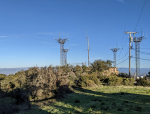
+ | [[File:BlackMountain-Site3-faa.png|thumb]] |
| − | [https://www.bay-net.org BAY-NET WW6BAY] |
||
Site located off the Black Mountain Trail near the Rancho San Antonio Open Space Preserve in the Los Altos Hills ([https://www.google.com/maps/@37.3201632,-122.1437596,18z map])([[Black Mountain Photos|photos]]) |
Site located off the Black Mountain Trail near the Rancho San Antonio Open Space Preserve in the Los Altos Hills ([https://www.google.com/maps/@37.3201632,-122.1437596,18z map])([[Black Mountain Photos|photos]]) |
||
| + | Road to the site is private and closed by a padlocked gate. The secure area at the site is managed by [https://www.crowncastle.com Crown Castle] using a timed bluetooth enabled key dropbox. There are a number of tower up at Black Mountain: |
||
| − | == Site Details == |
||
| − | None |
||
| + | * Site 1 - An old abandoned tower possibly still owned by Stanford University. Previously the site of the Stanford Amateur Radio Club ([[Black Mountain Site 1|W6YX]]) repeater and Stanford's Instruction TV. |
||
| − | === Plans === |
||
| + | * Site 2 - Commercial site, but with a small HAM building. |
||
| − | None |
||
| + | * Site 3 - FAA |
||
| − | |||
| + | * [[Black Mountain (Site 4)|Site 4 - The BAY-NET tower]] where AREDN is located |
||
| − | == Nodes == |
||
| + | * [[Black Mountain (Site 5)|Site 5 - WB6ECE Repeater Group]] |
||
| − | |||
| + | Site 1 is at the highest point. |
||
| − | === N9JIM-BlackMtn === |
||
| − | Radio: Ubiquiti Rocket M5 |
||
| − | |||
| − | Antenna: 120° sector |
||
| − | |||
| − | Location: 37.3201632, -122.1437596 |
||
| − | |||
| − | Altitude: Unknown |
||
| − | |||
| − | Bearing: 55° toward Sunnyvale |
||
| − | |||
| − | === N9JIM-PBE2 === |
||
| − | Radio: Ubiquiti PowerBeam M5 |
||
| − | |||
| − | Antenna: Built in |
||
| − | |||
| − | Location: 37.3201632, -122.1437596 |
||
| − | |||
| − | Altitude: 822m |
||
| − | |||
| − | Bearing: 356° toward Facebook Menlo Park |
||
| − | |||
| − | === N9JIM-HAP1 === |
||
| − | Radio: MikroTik hAP ac lite |
||
| − | |||
| − | Antenna: - |
||
| − | |||
| − | Location: 37.3201632, -122.1437596 |
||
| − | |||
| − | Altitude: - |
||
| − | |||
| − | Bearing: - |
||
| − | |||
| − | == Contacts == |
||
| − | |||
| − | * Jim Moss - N9JIM - n9jim@pacbell.net |
||
| − | * David Ranch - KI6ZHD - sfwem@trinnet.net |
||
Latest revision as of 23:22, 9 July 2023
Site located off the Black Mountain Trail near the Rancho San Antonio Open Space Preserve in the Los Altos Hills (map)(photos)
Road to the site is private and closed by a padlocked gate. The secure area at the site is managed by Crown Castle using a timed bluetooth enabled key dropbox. There are a number of tower up at Black Mountain:
- Site 1 - An old abandoned tower possibly still owned by Stanford University. Previously the site of the Stanford Amateur Radio Club (W6YX) repeater and Stanford's Instruction TV.
- Site 2 - Commercial site, but with a small HAM building.
- Site 3 - FAA
- Site 4 - The BAY-NET tower where AREDN is located
- Site 5 - WB6ECE Repeater Group
Site 1 is at the highest point.
