Mt Vaca: Difference between revisions
Jump to navigation
Jump to search
No edit summary |
No edit summary |
||
| (6 intermediate revisions by the same user not shown) | |||
| Line 1: | Line 1: | ||
| + | [[File:IMG 6175.jpeg|thumb]] |
||
| ⚫ | |||
| + | Mount Vaca is a mountain with the ridge line separating Napa and Solano counties. |
||
| ⚫ | |||
| − | * Site 1 - |
||
| + | |||
| − | * Site 2 - [[Mt Vaca Army Tower]] |
||
| + | * Site 1 - [[Vaca Valley Radio Club Repeater Site]] |
||
| − | * Site 3 - |
||
| + | * Site 2 - [[Mt Vaca Army Tower]]. N6ICW Repeater(?), [http://www.carlaradio.net CARLA] K6LNK Repeater(?) (map)([[Mt Vaca Army Tower Photos|photos]]) |
||
| − | * Site 4 - [[Mt Vaca East]] - County and SacARDN site |
||
| + | * Site 3 - American Tower ([https://www.google.com/maps/place/38°24'01.1%22N+122°06'18.0%22W/@38.3995369,-122.1049603,347m map])[[Mt Vaca Site 3 Photos|(photos)]] |
||
| + | * Site 4 - [[Mt Vaca East]] - County and [https://www.sac-aredn.org SacAREDN] site (map)([[Mt Vaca East Photos|photos]]) |
||
* Site 5 - |
* Site 5 - |
||
Latest revision as of 11:32, 10 November 2023
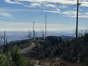
Mount Vaca is a mountain with the ridge line separating Napa and Solano counties.
A large number of tower sites are located on or near the ridge at the peak (map)(photos)
- Site 1 - Vaca Valley Radio Club Repeater Site
- Site 2 - Mt Vaca Army Tower. N6ICW Repeater(?), CARLA K6LNK Repeater(?) (map)(photos)
- Site 3 - American Tower (map)(photos)
- Site 4 - Mt Vaca East - County and SacAREDN site (map)(photos)
- Site 5 -
