Carpenter Hill: Difference between revisions
Jump to navigation
Jump to search
No edit summary |
No edit summary |
||
| Line 1: | Line 1: | ||
[[File:Carpenter Hill.jpg|thumb]] |
[[File:Carpenter Hill.jpg|thumb]] |
||
| − | https://www.sac-aredn.org/ |
||
| − | |||
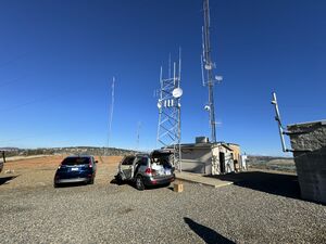
The Carpenter Hill (or Peak) site is locate at a Sacramento County Site on a hilltop near Folsom ([https://www.google.com/maps/place/38°38'58.0%22N+121°05'58.0%22W/@38.6494486,-121.1020193,1087m map])([[Carpenter Hill Photos|photos]]). |
The Carpenter Hill (or Peak) site is locate at a Sacramento County Site on a hilltop near Folsom ([https://www.google.com/maps/place/38°38'58.0%22N+121°05'58.0%22W/@38.6494486,-121.1020193,1087m map])([[Carpenter Hill Photos|photos]]). |
||
| Line 20: | Line 18: | ||
== Site Details == |
== Site Details == |
||
| − | The site is home to the Sac-AREDN club. |
+ | The site is home to the [https://www.sac-aredn.org/ Sac-AREDN] club. |
== Contacts == |
== Contacts == |
||
Revision as of 23:05, 29 November 2023
The Carpenter Hill (or Peak) site is locate at a Sacramento County Site on a hilltop near Folsom (map)(photos).
Part of the Bay Area Backbone.
Nodes
...
Backbone
CarpHill-to-MtVacaE
- Radio: Ubiquiti airFiber 5XHD
- Antenna: 34 dBi dish
- Location: -
- Altitude: -
- Bearing: -°
Site Details
The site is home to the Sac-AREDN club.
Contacts
Site Admin
- Tom Preston - KQ6EO - tpkq6eo@gmail.com
Mesh Admin
- Tom Preston - KQ6EO - tpkq6eo@gmail.com
