Black Mountain: Difference between revisions
Jump to navigation
Jump to search
No edit summary |
No edit summary |
||
| Line 1: | Line 1: | ||
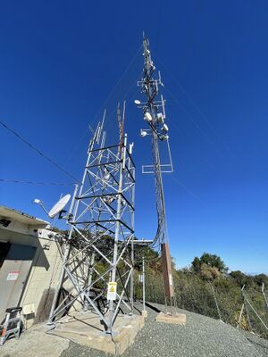
| − | + | [[File:BlackMountainTower2.jpg|thumb]] |
|
| + | [https://www.bay-net.org BAY-NET WW6BAY] |
||
| + | |||
Site located off the Black Mountain Trail near the Rancho San Antonio Open Space Preserve in the Los Altos Hills ([https://www.google.com/maps/@37.3201632,-122.1437596,18z map])([[Black Mountain Photos|photos]]) |
Site located off the Black Mountain Trail near the Rancho San Antonio Open Space Preserve in the Los Altos Hills ([https://www.google.com/maps/@37.3201632,-122.1437596,18z map])([[Black Mountain Photos|photos]]) |
||
Revision as of 21:57, 13 August 2022
Site located off the Black Mountain Trail near the Rancho San Antonio Open Space Preserve in the Los Altos Hills (map)(photos)
Site Details
None
Plans
The antenna is currently blocked by trees. We intend to move them it to a higher point on the tower on August 13th, 2022. This will improve the LoS to the South Bay (re: conversation with Marcel AI6MS, August 12th, 2022)
Nodes
N9JIM-BlackMtn
Radio: Ubiquiti Rocket M5
Antenna: 120° sector
Location: 37.3201632, -122.1437596
Altitude: Unknown
Bearing: 55° toward Sunnyvale
N9JIM-HAP1
Radio: MikroTik hAP ac lite
Antenna: -
Location: 37.3201632, -122.1437596
Altitude: -
Bearing: -
Contacts
- Jim Moss - N9JIM - n9jim@pacbell.net
- David Ranch - KI6ZHD - sfwem@trinnet.net
- Marcel Stieber - AI6MS - marcel.stieber@gmail.com
