Carpenter Hill: Difference between revisions
Jump to navigation
Jump to search
No edit summary |
|||
| (9 intermediate revisions by the same user not shown) | |||
| Line 1: | Line 1: | ||
[[File:Carpenter Hill.jpg|thumb]] |
[[File:Carpenter Hill.jpg|thumb]] |
||
| − | https://www.sac-aredn.org/ |
||
| − | |||
The Carpenter Hill (or Peak) site is locate at a Sacramento County Site on a hilltop near Folsom ([https://www.google.com/maps/place/38°38'58.0%22N+121°05'58.0%22W/@38.6494486,-121.1020193,1087m map])([[Carpenter Hill Photos|photos]]). |
The Carpenter Hill (or Peak) site is locate at a Sacramento County Site on a hilltop near Folsom ([https://www.google.com/maps/place/38°38'58.0%22N+121°05'58.0%22W/@38.6494486,-121.1020193,1087m map])([[Carpenter Hill Photos|photos]]). |
||
| Line 7: | Line 5: | ||
== Nodes == |
== Nodes == |
||
| + | |||
| − | ... |
||
| + | === W6AK-CARPPK1-3 === |
||
| + | |||
| + | * Radio: Ubiquiti Rocket M3 XM |
||
| ⚫ | |||
| + | * Location: 38.649285,-121.099479 |
||
| ⚫ | |||
| ⚫ | |||
| + | |||
| + | === W6AK-CARPPK2-5 === |
||
| + | |||
| + | * Radio: Ubiquiti Rocket M5 XW |
||
| + | * Antenna: 120° Sector |
||
| + | * Location: 38.649285,-121.099479 |
||
| + | * Altitude: 262 meters |
||
| + | * Bearing: 255° |
||
| + | |||
| + | === W6AK-CARPPK3-2 === |
||
| + | |||
| + | * Radio: Ubiquiti Rocket M2 XW |
||
| + | * Antenna: 120 Sector |
||
| + | * Location: 38.649285,-121.099479 |
||
| + | * Altitude: 262 meters |
||
| + | * Bearing: 255° |
||
| + | |||
| + | === W6AK-CARPPK4-3 === |
||
| + | |||
| + | * Radio: Ubiquiti NanoBridge M3 |
||
| + | * Antenna: |
||
| + | * Location: 38.649285,-121.099479 |
||
| + | * Altitude: 262 meters |
||
| + | * Bearing: 252° |
||
| + | * Notes: Pointing towards Mt Vaca providing original 3 GHz link. |
||
| + | |||
| + | === W6AK-CARPPK-HAP === |
||
| + | |||
| + | * Radio: Mikrotik hAP AC2 |
||
| + | * Antenna: Built-in (unused) |
||
| + | * Location: Inside the HAM Shack |
||
| + | * Altitude: - |
||
| + | * Bearing: N/A |
||
== Backbone == |
== Backbone == |
||
| + | [[File:IMG 6224.jpeg|thumb|200x200px|Looking towards Mt Vaca]] |
||
=== CarpHill-to-MtVacaE === |
=== CarpHill-to-MtVacaE === |
||
* Radio: Ubiquiti airFiber 5XHD |
* Radio: Ubiquiti airFiber 5XHD |
||
| + | * Frequency: 6.00 GHz |
||
| ⚫ | |||
| − | * |
+ | * Bandwidth: 30 MHz |
| + | * Antenna: [https://store.ui.com/us/en/pro/category/wireless-antennas/products/af-5g34-s45 airFiber X 5 GHz, 34 dBi, Slant 45] |
||
| ⚫ | |||
| + | * Location: 38.649285,-121.099479 |
||
| ⚫ | |||
| + | * Altitude: 262 meters |
||
| + | * Bearing: 252° |
||
| + | * Notes: Connecting to [[Mt Vaca East]] |
||
== Site Details == |
== Site Details == |
||
| − | The site is home to the Sac-AREDN club. |
+ | The site is home to the [https://www.sac-aredn.org/ Sac-AREDN] club. |
| + | |||
| + | === Future Plans === |
||
| + | |||
| + | * None |
||
| + | |||
| + | === Completed Work === |
||
| + | |||
| + | ==== February 2024 ==== |
||
| + | |||
| + | * Switch out Rocket LTU radio for airFiber 5XHD radio. Hoping a strict PtP connection will be more stable. |
||
| + | |||
| + | ==== January 2024 ==== |
||
| + | |||
| + | * Attempt to realign the dish to fix failed connection to [[Mt Vaca East]]. Failed, so must now do the other end. |
||
| + | |||
| + | ==== November 2023 ==== |
||
| + | |||
| + | * Installed new airFiber radio and dish pointed toward [[Mt Vaca East|Mount Vaca]]. |
||
| + | * Installed hAP ac2 to provide xlink over airFiber radio. |
||
| + | * Installed EdgeRouter X SFP to provide backbone functionality at site. |
||
== Contacts == |
== Contacts == |
||
Latest revision as of 10:40, 27 February 2024
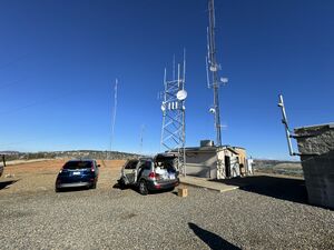
The Carpenter Hill (or Peak) site is locate at a Sacramento County Site on a hilltop near Folsom (map)(photos).
Part of the Bay Area Backbone.
Nodes
W6AK-CARPPK1-3
- Radio: Ubiquiti Rocket M3 XM
- Antenna: 120° Sector
- Location: 38.649285,-121.099479
- Altitude: 262 meters
- Bearing: 255°
W6AK-CARPPK2-5
- Radio: Ubiquiti Rocket M5 XW
- Antenna: 120° Sector
- Location: 38.649285,-121.099479
- Altitude: 262 meters
- Bearing: 255°
W6AK-CARPPK3-2
- Radio: Ubiquiti Rocket M2 XW
- Antenna: 120 Sector
- Location: 38.649285,-121.099479
- Altitude: 262 meters
- Bearing: 255°
W6AK-CARPPK4-3
- Radio: Ubiquiti NanoBridge M3
- Antenna:
- Location: 38.649285,-121.099479
- Altitude: 262 meters
- Bearing: 252°
- Notes: Pointing towards Mt Vaca providing original 3 GHz link.
W6AK-CARPPK-HAP
- Radio: Mikrotik hAP AC2
- Antenna: Built-in (unused)
- Location: Inside the HAM Shack
- Altitude: -
- Bearing: N/A
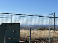
Backbone
CarpHill-to-MtVacaE
- Radio: Ubiquiti airFiber 5XHD
- Frequency: 6.00 GHz
- Bandwidth: 30 MHz
- Antenna: airFiber X 5 GHz, 34 dBi, Slant 45
- Location: 38.649285,-121.099479
- Altitude: 262 meters
- Bearing: 252°
- Notes: Connecting to Mt Vaca East
Site Details
The site is home to the Sac-AREDN club.
Future Plans
- None
Completed Work
February 2024
- Switch out Rocket LTU radio for airFiber 5XHD radio. Hoping a strict PtP connection will be more stable.
January 2024
- Attempt to realign the dish to fix failed connection to Mt Vaca East. Failed, so must now do the other end.
November 2023
- Installed new airFiber radio and dish pointed toward Mount Vaca.
- Installed hAP ac2 to provide xlink over airFiber radio.
- Installed EdgeRouter X SFP to provide backbone functionality at site.
Contacts
Site Admin
- Tom Preston - KQ6EO - tpkq6eo@gmail.com
Mesh Admin
- Tom Preston - KQ6EO - tpkq6eo@gmail.com

