Kings Mountain: Difference between revisions
Jump to navigation
Jump to search
mNo edit summary |
No edit summary |
||
| Line 5: | Line 5: | ||
=== Notes === |
=== Notes === |
||
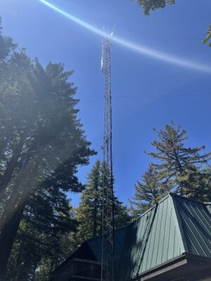
| − | Site is surrounded by tall tree. Despite the tower on the fire station, it seems like an impractical spot with no line-of-sight in any direction. |
+ | Site is surrounded by tall tree. Despite the tower on the fire station, it seems like an impractical spot with no line-of-sight in any direction (observed 16th Aug, 2022). |
| + | |||
| + | Discussions with Rachel (18th Aug, 2022) indicate the site has visibility across the bay but not back into the mountain. There are drone photos (so far unavailable). |
||
| + | |||
| + | == Contacts == |
||
| + | |||
| + | * Rachel Kinoshita - KK6AC - kk6dac@gmail.com |
||
Revision as of 20:51, 18 August 2022
South County Amateur Radio Emergency Services (K6MPN)
Site is located in the Woodside hills (map).
Site Details
Notes
Site is surrounded by tall tree. Despite the tower on the fire station, it seems like an impractical spot with no line-of-sight in any direction (observed 16th Aug, 2022).
Discussions with Rachel (18th Aug, 2022) indicate the site has visibility across the bay but not back into the mountain. There are drone photos (so far unavailable).
Contacts
- Rachel Kinoshita - KK6AC - kk6dac@gmail.com
